Mapping survey
By Lookout on Jun 14, 2016 with Comments 0
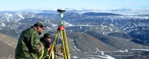
Photos by PO2 Belinda Groves, Task Force Imagery Technician
MCpl Corey Quinn and Cpl Mike Brajak from Canadian Forces Mapping and Charting Establishment Ottawa, Ontario mark boundary lines at the Grant High Arctic Data Communications System on June 11 during Operation NEVUS.
Filed Under: Featured
About the Author: