Yellowknife’s cooperation in the name of science
By Lookout on May 03, 2019 with Comments 0
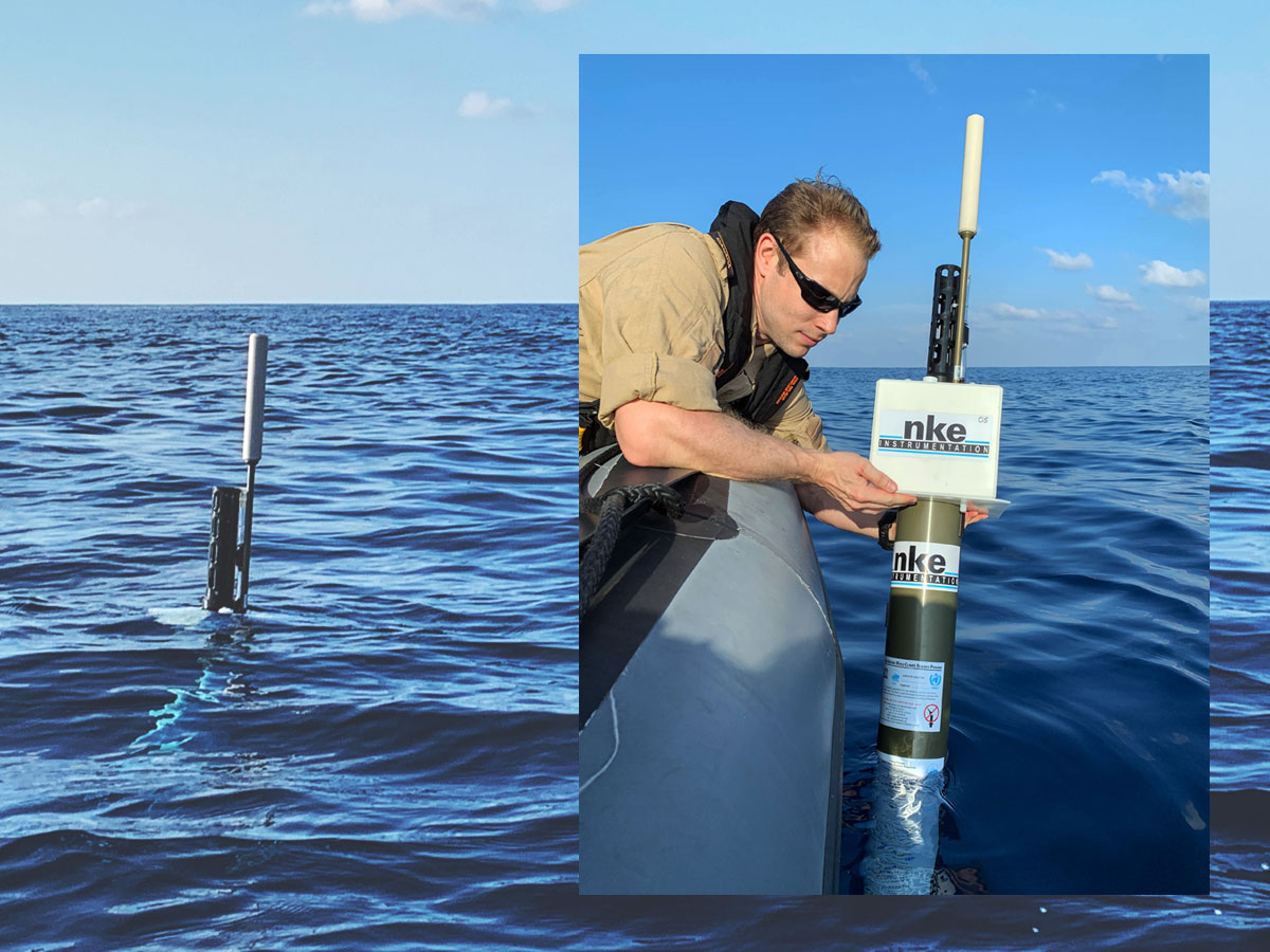
An officer from HMCS Yellowknife deploys an Argo float in the Pacific Ocean. Photo by Captain Annie Morin
Capt Annie Morin, Public Affairs Officer Operation Caribbe ~
Recently, HMCS Yellowknife was asked by the Department of Fisheries and Oceans (DFO) to water deploy an Argo float as part of a broad-scale global array of temperature/salinity floats.
This piece of equipment provides continuous monitoring of temperature, salinity, and the velocity of the upper ocean.
To gather the information, the Argo floats go through a cycle of approximately 10 days. The float first descends at a depth of approximately 1,000 meters and drifts for eight to 10 days. At that point, it descends further to about 2,000 meters before ascending to the surface over a period of approximately six hours where it will spend some time at the surface of the water to transmit its data. While submerged, the float collects water column information and data. The cycle is then repeated to gather and transmit new data.
“HMCS Yellowknife was presented with the opportunity to contribute to the gathering of oceanographic data and gladly accepted the offer,” said Lieutenant Commander Donald Thompson-Greiff, the ship’s commanding officer. “By supporting the Department of Fisheries and Oceans with the deployment of an Argo float off Latin America, we are able to help the collection of a range of data valuable for research.”
Debuted in 2000, the program activates about 800 floats each year which contributes to a greater understanding of the oceans. The data gathered by the floats is released near real-time to the Argo Global Data Centres located in Brest, France, and Monterey, California. Overall, the global network includes some 4,000 Argo floats around the world with over 30 participating nations in the program.
Lieutenant (N) Josée Belcourt, Maritime Forces Pacific Formation Oceanographer, was the liaison between DFO and the Royal Canadian Navy to facilitate deployment of the floats. She explains that the data gathered “provides valuable scientific information to monitor ocean variability, including [for example] rising sea levels, arctic sea ice, and the changing state of the upper ocean.”
“As the information is made publically available near real-time on the internet, the data can be used for educational purposes such as for classroom curriculum, scientist outreach workshops, and online tools for the general public. From an operational point of view, oceanographic centers around the world routinely validate and improve global and regional analyses of ocean properties using the Argo data stream, which is valuable information for the operations of the Royal Canadian Navy.”
The Institute of Ocean Sciences at DFO in Sidney, B.C., provided the float, which was embarked on Yellowknife before its departure on Operation Caribbe.
Crewed by 45 members, including members of the United States Coast Guard, HMCS Yellowknife is currently deployed with HMCS Whitehorse on Operation Caribbe, Canada’s contribution to Operation Martillo, a U.S. Joint Interagency Task Force South (JIATF-S) operation responsible for conducting interagency and international detection and monitoring operations and facilitating the interdiction of illicit trafficking.
Filed Under: Top Stories
About the Author: